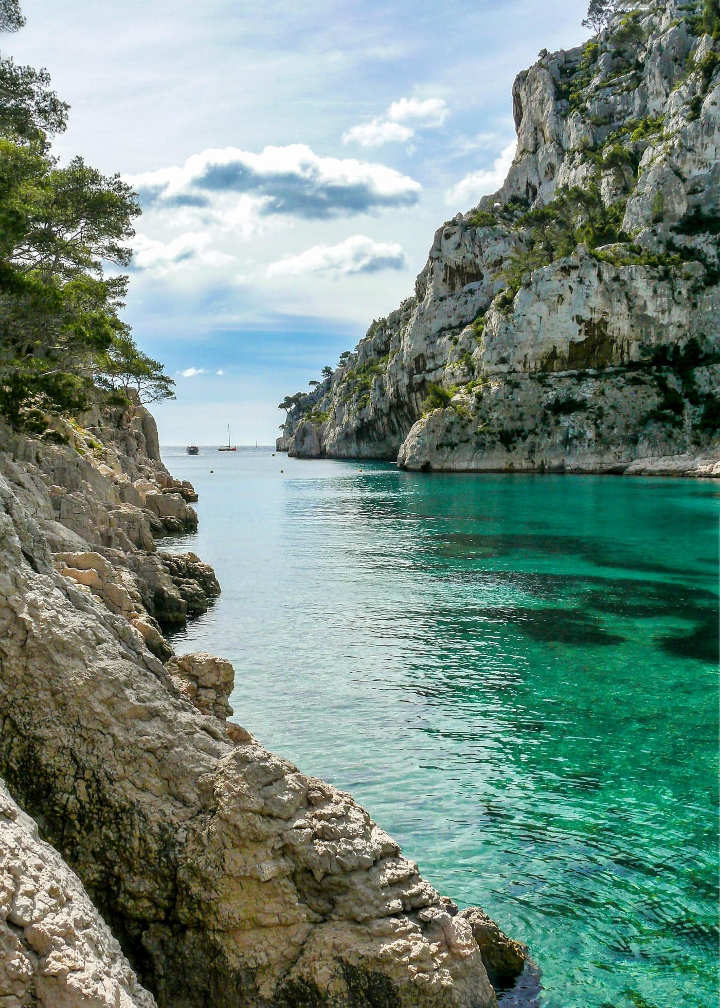

Where white limestone cliffs drop vertically into waters of impossible blue, where the Mediterranean reveals colors that seem digitally enhanced yet prove perfectly real, the Calanques stretch between Marseille and Cassis—a wilderness of stone and sea that constitutes one of Europe's great natural treasures.
A National Park Like No Other
The Parc National des Calanques holds unique distinction as Europe's only national park encompassing land, sea, and significant urban interface. Established in 2012 after decades of advocacy, the park protects 20 kilometers of coastline, 8,500 hectares of terrestrial environment, and 43,500 hectares of marine territory—all within sight of France's second-largest city.1
The term "calanque" defies simple translation. Derived from the Corsican word for inlet, it describes the narrow, steep-sided valleys that have been flooded by the Mediterranean, creating fjord-like formations in limestone rather than granite. These geological features—carved over millennia by rivers that now run underground, then drowned by rising sea levels—produce landscapes of striking drama: white cliffs hundreds of meters high, water transitioning from deep blue to brilliant turquoise, hidden beaches accessible only by hiking trails or boat.
The park's proximity to Marseille—the major calanques begin at the city's southern edge—creates both opportunity and challenge. Approximately three million visitors access the park annually, generating pressures on ecosystems never designed for such numbers.2 Management strategies including access restrictions during high fire-risk periods, visitor quotas for sensitive areas, and extensive educational programs attempt to balance preservation with public access.
Understanding the Calanques
Geology and Formation
The limestone that forms the Calanques was deposited during the Cretaceous period, approximately 120 million years ago, when this region lay beneath a shallow tropical sea. Subsequent tectonic activity uplifted these sediments, creating the Massif des Calanques—a rugged karst landscape where water has sculpted rock into dramatic forms.3
The characteristic calanque shape results from river erosion during ice ages, when sea levels dropped and Mediterranean rivers cut deep valleys reaching the distant shoreline. When seas rose again, these valleys flooded, creating the narrow inlets we see today. The process continues: the limestone dissolves slowly, caves develop and collapse, the coastline evolves on geological timescales.
Underground, this same limestone hosts extensive cave systems, including the remarkable Grotte Cosquer—a prehistoric decorated cave whose entrance now lies 37 meters below sea level. Discovered in 1985, the cave contains paintings and engravings dating from 27,000 to 19,000 years ago, created when the Mediterranean stood much lower and the cave entrance opened to dry land.4
Flora and Fauna
Despite appearing barren from certain angles, the Calanques support remarkable biodiversity. The terrestrial environment hosts over 900 plant species, many adapted to the challenging conditions of thin soil, intense sun, and maritime exposure.5
Characteristic vegetation includes:
- Aleppo pine (Pinus halepensis): The umbrella-shaped trees that provide the landscape's green accents
- Garrigue: Low, aromatic scrubland of rosemary, thyme, lavender, and cistus
- Endemic species: Plants found nowhere else, including several species adapted to the unique limestone microhabitats
The marine environment proves equally rich. Posidonia seagrass meadows—essential habitat for countless species—carpet the seabed in shallower areas. Marine protected zones within the park harbor populations of grouper, sea bass, and other species recovering after decades of overfishing. Occasional dolphin sightings reward patient boat travelers.
Bird life includes Bonelli's eagles, nesting on cliff faces; peregrine falcons; and various seabirds including the rare Yelkouan shearwater, which breeds in caves along the coast.
The Major Calanques
Calanque de Sormiou
The largest and most accessible of the major calanques, Sormiou lies within Marseille's city limits and maintains a small fishing settlement that predates the park. The calanque's relative accessibility—a road reaches the inlet, though parking restrictions limit vehicle access during summer—makes it popular with Marseillais seeking beach escape.
The beach itself, a mix of sand and pebbles, fronts turquoise water sheltered by the surrounding cliffs. Several restaurants (cabanons) serve fresh seafood and provide the essential infrastructure of shade, drinks, and facilities. The atmosphere combines natural beauty with genuine local character—this is where Marseille comes to swim, not a tourist-created destination.6
Hiking trails connect Sormiou to neighboring calanques, with routes varying from moderate coastal paths to challenging cliff traverses. The circuit to Morgiou takes approximately two hours and provides continuous spectacular views.
Calanque de Morgiou
Smaller and more intimate than Sormiou, Morgiou occupies a narrow inlet whose steep sides create an almost enclosed feeling. The calanque maintains a tiny community of traditional fishermen's houses (cabanons), some dating to the 19th century, that give the inlet its distinctive character.
Swimming here feels private despite other visitors—the scale creates intimacy, the surrounding cliffs provide drama, the water achieves the brilliant turquoise that photographs cannot capture accurately. Restaurant options are limited but authentic; fresh-caught fish prepared simply represents the essential Morgiou experience.
Access by foot from the Luminy area takes approximately one hour each way on a well-marked but moderately challenging trail. Vehicle access exists but is severely restricted during summer months.
Calanque d'En-Vau
If one calanque must represent the whole, En-Vau earns the designation. This narrow inlet, backed by towering cliffs and fronted by a small pebble beach, appears in virtually every promotional image of the region—and justifies the attention completely. The water color here, shifting from deep blue at the inlet's mouth to brilliant turquoise at the beach, achieves Mediterranean perfection.7
The challenge: En-Vau requires effort to reach. Hikers face approximately 90 minutes from the nearest parking area (Col de la Gardiole), including a steep descent that becomes challenging for those uncomfortable on rough terrain. Boat access provides an alternative, with operators from Cassis offering trips into the inlet.
The lack of any facilities—no restaurants, no bathrooms, no shade beyond what geology provides—means visitors must come prepared. Bring water, sun protection, food, and the understanding that this paradise requires self-sufficiency. The reward justifies the preparation.
Calanque de Port-Pin
Adjacent to En-Vau and often combined in the same hiking excursion, Port-Pin offers a gentler alternative. The inlet is wider, the beach more accessible, the approach hike less demanding. Pine trees (the "port-pin" of the name) provide welcome shade on the beach—a luxury absent from more dramatic neighbors.8
For families or those seeking spectacular scenery without extreme effort, Port-Pin delivers. The water quality matches anywhere in the Calanques; the setting, while slightly less dramatic than En-Vau, remains stunning by any reasonable standard.
Calanque de Port-Miou
The easternmost major calanque, Port-Miou extends inland for over a kilometer—the longest inlet in the chain. The calanque served as a quarry from Roman times through the 20th century, providing the white stone that built much of Mediterranean Provence. Quarrying scars remain visible on the cliffs, giving the inlet a somewhat industrial character that distinguishes it from more pristine neighbors.9
Today, Port-Miou functions primarily as a marina, its sheltered waters hosting hundreds of pleasure boats. The absence of beach limits swimming appeal, but the inlet provides the easiest access point for boat trips into the calanques and makes an atmospheric starting point for coastal walks.
From the parking area at Port-Miou, trails lead west toward Port-Pin and En-Vau, beginning the classic calanques hiking experience.
Experiencing the Calanques
Hiking: The Essential Experience
Walking remains the most rewarding way to experience the Calanques—the changing perspectives, the gradual revelation of each inlet, the Mediterranean constantly appearing and disappearing as trails wind through the landscape. The park offers approximately 140 kilometers of marked trails ranging from gentle coastal walks to demanding technical routes.10
Classic day hikes include:
Port-Miou to En-Vau and return (approximately 4-5 hours): The essential Calanques experience, combining three major inlets with consistently spectacular scenery. The terrain requires reasonable fitness and sure-footedness, particularly on the steep descent into En-Vau.
Callelongue to Marseilleveyre (approximately 3 hours): Starting from Marseille's edge, this route climbs to panoramic viewpoints before descending to a small beach. Less trafficked than the Port-Miou routes.
Luminy to Sormiou (approximately 1.5 hours each way): A moderate route connecting the university campus area to the popular beach, offering flexibility for swimming breaks.
Important considerations:
- Trails close when fire risk reaches critical levels (typically July-August during mistral wind conditions). Check daily access reports before setting out.
- Bring more water than you think necessary—at least 2 liters per person, more in hot weather.
- Sun protection is essential; shade is scarce.
- Proper footwear is mandatory; the limestone terrain punishes inappropriate shoes.
- Start early in summer to avoid midday heat and secure parking.
By Boat: The Marine Perspective
Boat excursions offer an alternative perspective—viewing the cliffs from water level, accessing calanques without hiking, and experiencing the marine environment that constitutes most of the park's protected area.
Operators from Cassis offer various itineraries:
- Short trips (45 minutes) visiting 3-5 calanques without stops
- Half-day excursions with swimming stops in selected inlets
- Full-day adventures exploring the coastline comprehensively
Operators from Marseille cover the western calanques and offer urban departure convenience.
Private boat rental provides maximum flexibility for those comfortable operating small craft. Several companies rent motorboats (no license required for craft under 6CV) from Cassis harbor.
The boat perspective reveals aspects invisible from land: the scale of the cliffs appearing even more impressive from below, the water colors shifting with depth and position, the coastal ecology of caves, arches, and hidden coves.
Swimming and Beach Time
While hiking provides access to the calanques, swimming justifies the effort. The water quality throughout the park is exceptional—clear, clean, typically warm from June through September. The swimming experience ranges from developed beaches with facilities to remote coves requiring complete self-sufficiency.
For easier swimming access:
- Sormiou: Road access (limited), restaurants, facilities
- Port-Pin: Moderate hike, natural shade, family-appropriate
- Plage de l'Huveaune (Pointe Rouge): Urban beach within Marseille, not a calanque but accessible and popular
For more adventurous swimmers:
- En-Vau: Challenging hike, no facilities, maximum reward
- Morgiou: Moderate access, excellent water, authentic atmosphere
- Sugiton: Accessible from Luminy, often crowded but beautiful
Safety considerations: The Mediterranean appears benign but demands respect. Pay attention to currents near inlet mouths; avoid swimming alone in remote areas; remember that return hikes require energy that swimming depletes.
Practical Planning
Access Points and Approaches
From Marseille (western calanques):
- Callelongue: Road access to this small harbor; trails continue into the park
- Les Goudes: Fishing village at Marseille's southern edge; boat access possible
- Luminy: University campus area with parking and trail access to Sugiton, Morgiou
From Cassis (eastern calanques):
- Port-Miou: Primary trailhead for En-Vau, Port-Pin; parking available
- Col de la Gardiole: Higher access point reducing descent into calanques
- Cassis harbor: Boat excursion departures
Parking reality: Summer weekends see parking areas fill before 9:00 AM. Early arrival is essential, or consider public transportation alternatives. Marseille's bus system serves some access points; Cassis is reachable by train from Marseille.
When to Visit
Spring (April-June): Ideal conditions with comfortable temperatures, wildflowers in bloom, and manageable visitor numbers. Water becomes swimmable by mid-May for most visitors.
Summer (July-August): Peak season brings heat, crowds, and potential access closures due to fire risk. Early morning visits essential; check daily access status; accept that popular calanques will be crowded.
Autumn (September-October): Excellent conditions with warm water, diminishing crowds, and stable weather. Arguably the best overall visiting season.
Winter (November-March): Trails remain accessible (no fire restrictions), fewer visitors, dramatic atmosphere when the mistral clears the air. Water too cold for most swimmers but hiking rewards remain.
Access Restrictions
The park implements access restrictions during high fire-risk periods, typically affecting July and August. These restrictions:
- May close trails entirely on dangerous days
- May limit access to early morning hours
- Apply without exception; rangers enforce compliance
Check before visiting at the park website or by calling the access information line. Disappointment at finding trails closed hurts less than causing the fire that destroys the landscape.
Where to Stay
Cassis offers the most convenient base for exploring the eastern calanques. This charming fishing port provides accommodation ranging from simple hotels to elegant properties, restaurants of all categories, and the relaxed Mediterranean atmosphere that complements calanques adventures.
Marseille suits visitors combining calanques exploration with urban experiences. The city's regenerated harbor areas and vibrant culture justify time beyond park visits. Access to western calanques is easier from Marseille.
La Ciotat, east of Cassis, offers a lower-key alternative with good beaches and reasonable calanques access.
The Calanques Experience
Why It Matters
The Calanques represent something increasingly rare: wilderness adjacent to urban civilization, maintained through continuous effort rather than mere isolation. That three million annual visitors can experience this landscape while ecosystems continue to function demonstrates what thoughtful management achieves.
The park also provides essential context for understanding Mediterranean ecology. The garrigue vegetation, the limestone formations, the marine environment: these constitute the natural heritage of an entire basin, compressed here into an accessible case study. What visitors learn about ecological relationships in the Calanques applies throughout the Mediterranean world.
The Reward of Effort
Unlike many spectacular destinations, the Calanques cannot be experienced passively. Reaching the best calanques requires walking; appreciating the marine environment requires swimming or boating; understanding the ecosystem requires attention and patience. This barrier of effort acts as a filter, selecting for visitors willing to engage actively with the landscape.
The result: moments of genuine discovery remain possible. The first view of En-Vau appearing below as the trail crests a ridge; the sensation of swimming in water so clear the seabed seems within arm's reach; the solitude of a remote cove reached by longer hiking: these experiences reward those who earn them.
In an age when spectacular scenery is often reduced to photo opportunities—quick visits, captured images, departure—the Calanques insist on different terms. They demand time, effort, and physical presence. They repay these investments with experiences that photographs cannot fully capture and memory struggles to contain.
Frequently Asked Questions
Can I visit the Calanques without hiking?
Yes, though options are limited. Boat excursions from Cassis and Marseille allow viewing the calanques from the water without walking. Sormiou is accessible by road (with restrictions). However, the most spectacular calanques require hiking to reach.
Are the Calanques suitable for children?
Some calanques suit families—Sormiou and Port-Pin offer easier access and more manageable swimming conditions. The hike to En-Vau challenges many children and may frustrate families with young kids. Boat trips provide family-friendly alternatives.
How difficult are the hiking trails?
Difficulty varies considerably. Trails to Sormiou and Port-Pin are moderate, suitable for anyone with basic fitness. The descent into En-Vau requires confidence on steep, rocky terrain. The park's long-distance routes demand serious hiking experience.
What should I bring for a day in the Calanques?
Essential items include: at least 2 liters of water per person (more in summer), sun protection (hat, sunscreen, sunglasses), sturdy hiking shoes, swimming gear if planning to swim, food (no facilities in most calanques), and a bag for carrying out all trash.
Is swimming safe in the Calanques?
Generally yes, with appropriate precautions. Avoid swimming near inlet mouths where currents may be strong. Be aware of boat traffic in areas frequented by excursion craft. Never swim alone in remote areas. The water is clean and safe; human hazards exceed natural ones.
When are the Calanques closed?
Closure typically occurs during extreme fire risk conditions in summer—days with high temperatures, low humidity, and strong mistral wind. Closures are announced daily; check the park website or call the information line before visiting during July-August.
References
- Parc National des Calanques. "Creation and Mission Statement." Official Documentation, 2012.
- French National Parks Authority. "Visitor Statistics: Mediterranean Parks 2023." Paris, 2024.
- Blanc, J.J. "Géologie des Calanques et du Massif de Marseilleveyre." CNRS Publications, 2006.
- Clottes, J. & Courtin, J. "La Grotte Cosquer: Peintures et Gravures de la Caverne Engloutie." Seuil, 1994.
- Médail, F. & Quézel, P. "Biodiversity Hotspots in the Mediterranean Basin." Conservation Biology, 1997.
- Parc National des Calanques. "Calanque de Sormiou: Site Guide." Marseille, 2022.
- Provence-Alpes-Côte d'Azur Tourism. "The Calanques: Hiking and Access Guide." Official Publication, 2023.
- Parc National des Calanques. "Trail Descriptions and Difficulty Ratings." Park Documentation, 2023.
- Commune de Cassis. "Port-Miou: Historical and Contemporary Uses." Municipal Archives, 2019.
- Fédération Française de la Randonnée Pédestre. "Les Calanques: Topoguide." FFRandonnée, 2022.